
ONLINE EDITION!
PRINT
DIGITAL

EAT, DRINK & PLAY - GET OUT OF TOWN
Get Out of Town!
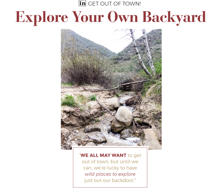
Explore Your Own Backyard
June, 2020 - Issue #189
 |
We can't get out of town right now. But getting out of the house is more important than ever. After days of Zoom meetings and online learning, we need the weekends to trade screen time for sunshine and ward off that feeling of impending claustrophobia.
So where can you go? With the pandemic curtailing ramblings further afield, I have been exploring my own backyard in Castaic, particularly along Lake Hughes Road. Winding through the rugged Sierra Pelona, the mountains north of the Santa Clarita Valley that are part of the sprawling Angeles National Forest, the road serves as a jumping-off point for adventures into terrain that feels much farther from home.
The closest is Castaic Rock. That may not be an official name, but that's how you'll find it on Google Maps. From the intersection of Ridge Route Road and Lake Hughes Road head north on Lake Hughes. You'll have vistas of Castaic Lake on your left. On the right, after about six miles of driving, you'll see a narrow, unmarked trail that climbs quickly away from the road. Park there, and follow the trail to the top of the ridge line. It winds through the brush for a half-mile or so before depositing you at the foot of a bald knob of reddish otherworldly rock.
You're approaching it from the backside, so it might not appear too impressive at first. Various paths bend around the base, or you can pick your way to the top. Either way, choose your steps carefully. The sheer back side of the rock protrudes high above the canyon below. The views of the surrounding mountains are worth the scramble, but the exposure requires vigilance.
Splashing in a creek is an experience I associate with the Sierra Nevada, not Santa Clarita. But continue driving north on Lake Hughes Road another six miles, and it's possible to find running water. The late spring rains painted brown hillsides green with purple, pink and yellow accents, and revived dry creek beds into flowing water courses.
A wide pullout on the right marks the beginning of Forest Service Road 6N24, which leads into Ruby Canyon. Park there and descend a quarter-mile or so on foot to another wide spot where you'll find a sandy section of shoreline perfect for a picnic.
If it's occupied, keep walking along 6N24. Within the next mile it will take you across the creek five or six times. Along the way you'll have your pick of places to sit and listen to water run in the creek and the wind move through the canopy of trees. Just know that as you're walking, you'll share the road with the occasional dirt bike or four-wheel-drive truck traversing the 8 miles of 6N24 that connects Lake Hughes Road with San Francisquito Canyon Road.
Another mile or so north on Lake Hughes Road you can also walk alongside a creek. Look for a small parking area on the left, in front of the now-shuttered Warm Springs county rehabilitation center. A large white gate limits traffic to hikers and mountain bikers.
Head west into Warm Springs Canyon following another Forest Service Road, 6N32. It traces the bends of the creek under a shady canopy of trees. The gentle grade allows for an easy stroll, especially if you have younger kids with you.
Eventually the road leaves the creek to ascend the canyon's northern flank. Keep going to challenge yourself with a deeper push into the largely deserted Sierra Pelona backcountry. The road links to other Forest Service Roads that lead to the top of Warm Springs Mountain. AllTrails.com provides a good description of the 13.1-mile roundtrip route.
We all may want to get out of town, but until we can, we're lucky to have wild places to explore just out our backdoor.
Eric Harnish lives and explores in Castaic.
Explore SCV's Backyard
Get a Lay of the Land Maps.google.com
Trail Off in the SCV AllTrails.com
Map Angeles National Forest fs.usda.gov/angeles

|
||||||||||||||||||||||||||||