
ONLINE EDITION!
PRINT
DIGITAL

EAT, DRINK & PLAY - GET OUT OF TOWN
Get Out of Town!
Extending Spring with a Malibu Adventure
June, 2022 - Issue #211
 |
It's nearly 10am as I follow the fire road into Sycamore Canyon. Although the sun is shining bright, it's still cool down here amid the shade of oaks and profusion of greenery.
In Santa Clarita our hills have already browned. Like every year, spring was a fleeting visitor. But here in Malibu, it settles in and stays awhile, prompted to linger by the moist air, gentle breezes and cooler temperatures.
With a couple of hours available to hike on a Saturday morning, I'm able to experience much of what Pt. Mugu State Park has to offer and savor a bit of that extended spring.
After a flat mile or so on Sycamore Canyon Fire Road, I duck on to Fireline Trail, a single track that winds its way up the north flank of the canyon. It's steep in places, and shade is sparse, but a steady breeze keeps me from getting too hot. Yucca dot the mountainside, their white plumage standing tall and straight above the surrounding chaparral. Sage shows off its bountiful purple blooms. Here and there, flashes of red and yellow from wildflowers contrast with the greenery. As I climb higher, the distant Boney Peak becomes more visible, eventually dominating the inland vistas.
After a short, steep push I find a random picnic table that marks the intersection with the aptly-named Overlook Fire Road. A wedge of ocean at the mouth of the canyon is now in view, and I can look back down into the canyon from which I ascended.
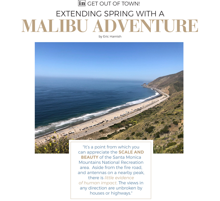
Heading inland, I stay on the fire road for about three-quarters of a mile, diverting briefly to reach a rocky promontory overlooking the surrounding mountains with the Pacific Ocean in the distance. It's a point from which you can appreciate the scale and beauty of the Santa Monica Mountains National Recreation area. Aside from the fire road, and antennas on a nearby peak, there is little evidence of human impact. The views in any direction are unbroken by houses or highways.
I continue on the fire road until reaching a spur of the Ray Miller Backbone Trail. The main path travels around the mountain, but this detour goes up and over. More work, certainly. But also, more rewarding. I pause at the crest to both catch my breath and savor the moment.
Though I have crossed paths with other hikers throughout the morning, I have this mountaintop to myself. It seems everyone else was dissuaded by the route's vertical gain.
From here, the ocean stretches to the horizon. Its swells appear to be faint ripples on a monochrome surface. To the north sits Santa Cruz Island, seemingly hovering in a misty haze. A gentle breeze rustles the cheery yellow mustard and carries first a white butterfly, and then an orange one, on their fluttering paths. Traffic winds silently along the sliver of Pacific Coast Highway visible far below. A small plane grinds overhead and a lone seagull wings south at eye level.
The descent leads me back to the Ray Miller Backbone Trail and closer to civilization. As I pick my way down the steep, rocky trail, the sound of breaking waves at Thornhill Broome Beach becomes audible. And too, the traffic along PCH. The scent of charcoal from a lunchtime barbecue drifts up from the campground.
Trails branch off in different directions here, and some are less visible than others due to spring growth. With the help of maps from the AllTrails app downloaded to my phone, I'm able to stay on course toward the Sycamore Canyon Campground below. But I'm not particularly eager to finish.
I'll be driving back to Santa Clarita soon enough, so for now I'll enjoy this extra taste of spring.
Eric Harnish lives in Castaic.
Go For A Hike
Hiking Sycamore Canyon
insidescv.com/sycamorecyn
Using an app like AllTrails that lets you download maps to your phone for offline navigation is recommended.

|
||||||||||||||||||||||||||||