
ONLINE EDITION!
PRINT
DIGITAL

EAT, DRINK & PLAY - GET OUT OF TOWN
Get Out of Town
Take a Hike!
March, 2023 - Issue #218
 |
If green means go, then the mountains around Santa Clarita are displaying a clear sign that now is the time to explore.
They have come alive thanks to the winter rains, beckoning us to bask in their emerald splendor. And, whether you hike, bike or drive, the mountains offer plenty of options to suit your preferred mode of exploration.
One of my favorite hikes just outside Santa Clarita is Fish Canyon. This 10-mile, out-and-back ramble is at the far north end of Castaic Lake. Reach it by following Templin Highway east after exiting Interstate 5. Continue on the road until you reach the concrete barriers. Park, and then begin walking downhill on the paved road.
Not long after the pavement ends, the road forks. Head left on what maps call Warm Springs Fish Canyon Truck Trail. It leads into a canyon and will take you across a flowing creek several times on the way to the abandoned Cienaga Campground.
Look for a small trail on your left that leads north out of the campground. This will bring you to Fish Canyon Narrows, where the hike turns from beautiful to spectacular. The canyon walls close in while also climbing high. Wander up the creek as far as you like and revel in the flowing water, seasonal greenery and isolation.
Looking to explore on your mountain bike? Check out Whitaker Peak. It too is accessible off Templin Highway. Turn west after exiting Interstate 5, then go north on Golden State Highway for about two miles. Look for a brown sign on the left pointing to Whitaker Peak. Park alongside the road and then start riding the fire road uphill past the white gate.
The climb begins immediately and doesn't let up - but the reward is an expanding panoramic view of the Santa Clarita Valley and surrounding mountains. After two miles or so, you'll come to a cluster of antenna towers. It's a good place to catch your breath and admire the view.
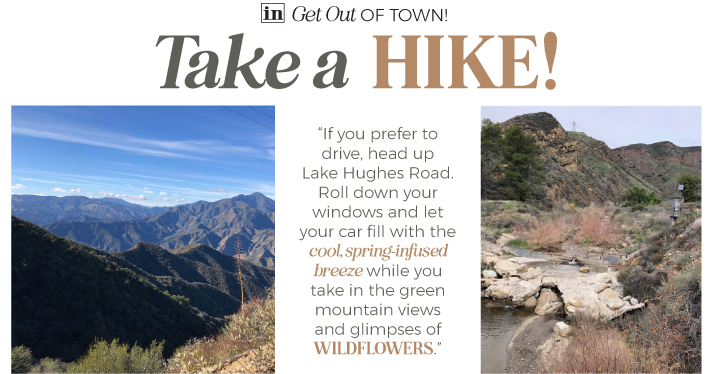
"If you prefer to drive, head up Lake Hughes Road. Roll down your windows and let your car fill with the cool, spring-infused breeze while you take in the green mountain views and glimpses of WILDFLOWERS."
If you prefer to drive, head up Lake Hughes Road. Roll down your windows and let your car fill with the cool, spring-infused breeze while you take in the green mountain views and glimpses of wildflowers.
On your right, look for Forest Route 6N24, shown on some maps as Ruby Clearwater Road. It's a short descent on the dirt road to the creek where there is plenty of room to pull over for a picnic. If you have the right vehicle, and the skills to drive offroad, you can follow 6N24 eight miles to San Francisquito Canyon Road.
Or, if you want to extend the offroad adventure, turn north on Forest Route 7N01. That's what my daughter Amber and I did on a recent outing. The dirt road climbs along the ridge lines, giving you breathtaking views of San Francisquito Canyon and the surrounding Angeles National Forest. It also bisects the Pacific Crest Trail. We followed 7N01 all the way to Lake Hughes, stopping for a delicious lunch at the historic Rock Inn before returning home.
Don't wait too long to savor spring and its fleeting greenery. Summer will be here soon enough, returning our mountains to their customary shades of dull brown.
Let's Go!
Before you hit the trail...
Check road conditions: insidescv.com/angelesfsalerts
Download maps from your favorite trail app to your phone, as cell service is often unreliable in the mountains.
Eric Harnish lives and wanders in Castaic.

|
||||||||||||||||||||||||||||